Detailed description
To view the map area,
sign in or create account
sign in or create account
25.79 59.15, 25.87 59.20
Identity Description
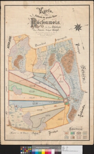
| Title | Karte vom Hofslande des privaten Gutes Rackamois. |
|---|---|
| Map type | Single sheet map |
| Reference code | EAA.3724.4.472 sheet 1 |
Creators
| Firstname | Lastname | Occupation of cartographer | Creators position |
|---|---|---|---|
| F. | Falkenberg | vannutatud maamõõtja | cartographer |
Cartographical and Publishing Description
| Main subject | Not set |
|---|---|
| Material designaton | plan |
| Manuscript/Printed | manuscript original |
| Created | 1891 |
Components and Mathematical Description
| Components | compass |
|---|---|
| Azimuth | Not set |
| Textual scale | 300 sülda |
| Relative scale | Not set |
Geographical Description
| Admin unit | Specification |
|---|---|
| Estonia (to 1917) / Estonia Guberniya / Järva County / Ambla Parish / Raka Manor |
Physical Description
| Storage form | Not set |
|---|---|
| Material and mounting | paper+textile |
| Medium | ink+coloured |
| Dimensions (cm) | 101x66/A0 |
| Access-restrictions | No access restriction |