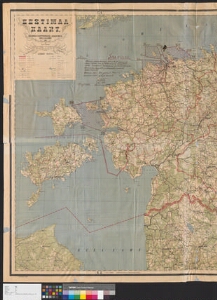
Detailed description
To view the map area,
sign in or create account
sign in or create account
21.79 57.51, 28.41 59.69
Identity Description
| Title | Eestimaa kaart |
|---|---|
| Map type | Single sheet map |
| Reference code | ERA.496.4.181 sheet 4 |
Creators
| Firstname | Lastname | Occupation of cartographer | Creators position |
|---|---|---|---|
| A. | Villard | sõjaväe kartograaf | author of base map |
Cartographical and Publishing Description
| Main subject | military |
|---|---|
| Material designaton | map |
| Manuscript/Printed | printed |
| Published by | Sõjaväe Kartograafia jaoskond, 1921 |
| Base map(s) year | 1921 |
| Created | 1921 - 1924 (Estimated) |
Components and Mathematical Description
| Components | legend for symbols |
|---|---|
| Azimuth | Not set |
| Textual scale | 1:300 000 |
| Relative scale | Not set |
Geographical Description
| Admin unit | Specification |
|---|---|
| Estonia (1917-1950) |
Physical Description
| Storage form | folder |
|---|---|
| Material and mounting | paper |
| Medium | printed+coloured |
| Dimensions (cm) | 108x138/2A0 |
| Access-restrictions | No access restriction |