Detailed description
To view the map area,
sign in or create account
sign in or create account
24.36768 56.65502, 27.39990 58.22744
Identity Description
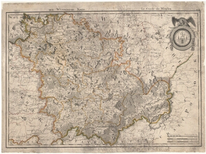
| Title | Der Wendensche Kreis. Le Cercle de Wenden |
|---|---|
| Map type | Subsheet |
| Reference code | EAA.2059.1.1464 sheet 10 |
Belongs to main sheet
EAA.2059.1.1464 sheet 1
Notes
Maakondade piirid, kihelkondade piirid; stiliseeritud leppemärkidega linnad, pastoraadid, kirikud, mõisad, külad, tuuleveskid, vesiveskid; teedevõrk; vetevõrk; kaunistatud pealkirjaraam, graafiline mõõtkava
Creators
| Firstname | Lastname | Occupation of cartographer | Creators position |
|---|---|---|---|
| Ludwig August krahv | Mellin | Landrath des Herzogthums Liefland | cartographer |
Cartographical and Publishing Description
| Main subject | Not set |
|---|---|
| Material designaton | map |
| Manuscript/Printed | printed |
| Created | 1798 |
Components and Mathematical Description
| Components | illustrated, compass, graphical scale |
|---|---|
| Azimuth | Not set |
| Textual scale | Maasstaebe Werst au 104½ auf einen Grad des AEquators = 30,1 cm |
| Relative scale | 370000 |
Geographical Description
| Admin unit | Specification |
|---|---|
| other / Europe Continent / Northern Europe Region / Latvia | |
| Estonia (to 1917) / Livonia Guberniya |
NB! location is approximate
Physical Description
| Storage form | streched |
|---|---|
| Material and mounting | paper+textile |
| Medium | printed |
| Dimensions (cm) | 53x73/A1 |
| Access-restrictions | No access restriction |
Maps referred to by this map
| Reference code | Relation |
|---|---|
| EAA.854.4.470 sheet 4 | duplicate |
| EAA.1365.1.31 sheet 13 | duplicate |
| EAA.2059.1.1464 sheet 2 | duplicate |
Maps referring to this map
| Reference code | Manuscript/Printed |
|---|---|
| EAA.2059.1.1464 sheet 2 | printed |