Detailed description
To view the map area,
sign in or create account
sign in or create account
25.21 59.25, 26.43 59.54
Identity Description
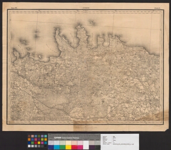
| Title | Рядъ III. г. Эстляндской. Листь 5 [Vabadussõja kaart] |
|---|---|
| Map type | Single sheet map |
| Reference code | ERA.2124.2.1088 sheet 5 |
Cartographical and Publishing Description
| Main subject | military |
|---|---|
| Material designaton | map |
| Manuscript/Printed | printed |
| Base map(s) year | 1866 |
| Created | 1920 |
Components and Mathematical Description
| Components | Not set |
|---|---|
| Azimuth | Not set |
| Relative scale | 126000 |
Geographical Description
| Admin unit | Specification |
|---|---|
| Estonia (1917-1950) / Harju County / Kuusalu Commune (1938-1950) | |
| Estonia (1917-1950) / Viru County / Rakvere Commune (1938-1950) |
Physical Description
| Storage form | streched |
|---|---|
| Material and mounting | paper |
| Medium | printed+coloured |
| Dimensions (cm) | 48x65/A1 |
| Access-restrictions | No access restriction |
Maps referring to this map
| Reference code | Manuscript/Printed |
|---|---|
| ERA.2124.2.1088 sheet 1 | printed |