Detailed description
To view the map area,
sign in or create account
sign in or create account
15.56763 58.17997, 25.85083 65.95364
Identity Description
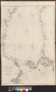
| Title | Карта Ботническаго залива./ Chart of part of the Gulf of Bothnia. |
|---|---|
| Map type | Subsheet |
| Reference code | EAA.1414.2.35 sheet 13 |
Belongs to main sheet
EAA.1414.2.35 sheet 12
Creators
| Firstname | Lastname | Occupation of cartographer | Creators position |
|---|---|---|---|
| Leonti | Spavarijev | kindralmajor | cartographer |
Cartographical and Publishing Description
| Main subject | hydrographic |
|---|---|
| Material designaton | map |
| Manuscript/Printed | printed |
| Published by | Mereväe trükikoda, 1823, St. Peterburg |
| Created | 1816 |
Components and Mathematical Description
| Components | illustrated, compass, graphical scale |
|---|---|
| Azimuth | Not set |
| Textual scale | erinevad mõõtkavad |
| Relative scale | Not set |
Geographical Description
| Admin unit | Specification |
|---|---|
| other / Europe Continent / Northern Europe Region / Sweden | Botnia laht |
| other / Europe Continent / Northern Europe Region / Finland |
Physical Description
| Storage form | atlas |
|---|---|
| Material and mounting | paper |
| Medium | ink |
| Dimensions (cm) | 66x98/A0 |
| Access-restrictions | No access restriction |